
Location > Nepal > Nar Phu
Overview
So little of the mysterious lands of Nar and Phu near the border with Tibet is known to the rest of the world - even to this day.
The region was first opened to foreign tourists in the early 2000s after the current trail from the gateway town of Koto was cut. A far older trail is said to have existed, but it was a seasonal trail that disappeared into rising waters whenever the gorge was fed by Monsoon rains during the summer months. The Kang La pass was the only other feasible way. In 1956, soon after the kingdom of Nepal was opened to outsiders, Himalayan scholar and explorer David Snellgrove used the pass to reach Nar. Even he described the pass as “long” and “difficult”.
Today, the Kang La pass remained a serious undertaking even in the warmer ice-free months. But passage is totally possible for the intrepid traveller, with some preparation and local support. During the rainy season, the woodland trail from Koto to Nar Phu is slick, and even unstable. Blood-thirsty leeches will be your faithful companions. By mid-winter, most of the inhabitants of Nar Phu would have migrated to warmer climes. Some would have gone as far as Kathmandu, if they had family there.
Then comes spring.
The many meadows in Nar Phu’s upper valleys become alive again, transforming the region into a naturalist’s paradise.
By the summer, with the growing season in full swing, Nar Phu is teeming with life – fields of swaying barley, animals grazing in the meadows.
After the autumn harvest, and as Nar Phu prepares to go dormant once more, a certain wildness returns to the land. The valleys are unclad and bare in their native brown, their inhabitants either indoors or away. The Buddhist monasteries are empty shells. The way to the Kang La pass becomes cold and desolate.
But even then, an untamed magic hangs in the air, felt only by the most adventurous (and most adequately outfitted) of off-season travellers.
This raw Nar Phu trek can easily be combined with the Annapurna Circuit for a spectacular exploratory trip.
Day 1: Arrive in Nepal’s bustling capital of Kathmandu
The vast majority of visitors from around the world fly into Kathmandu, a sprawling city of more than 1.6 million people. As you step out of Tribhuvan International Airport, you will be greeted by your guide or a company representative who will drive you to your hotel. After finalising your itinerary with your guide at the hotel and answering any remaining questions you might have, you are free to go explore the warrens of colourful alleyways and tourist attractions in downtown Kathmandu. Restaurants, bars and shops open till late during peak tourist seasons.
Day 2: Kathmandu to Koto (2620m)
Today’s long drive to Koto, the trailhead of the trek, calls for an early start. As you drive west, Kathmandu’s whirring web of winding roads and alleyways quickly disappear into the rear view mirror. Once out of the Kathmandu valley, you slip into the busy NH17, or the Prithvi Highway, which connects the capital with the lakeside city of Pokhara. Pass by picturesque villages and terraced fields along the Prithvi Highway, named after the first monarch (1723-1775) of the unified Kingdom of Nepal. After your lunch stop, you make a sharp turn and enter a narrow valley. The tarred motorway soon becomes a single-lane road of dirt and potholes. Driving exclusively on steep slopes from this point, your route runs parallel to the Marsyangdi, a river that will undergo an irreversible change when a Chinese-funded hydropower project is completed despite objections from local communities. By the late afternoon or early evening, you arrive at the town of Koto (2620m/8596ft), where snow-capped peaks unexpectedly come into view.
Day 3: Koto to Cha Cha (2960m)
After an early breakfast at your lodge, your paperwork will be verified by the police at the Koto checkpoint. To enter Nar Phu, you need to pay for a special permit, which is needed for many areas that share an international border with Tibet in China. Nepal Himal would have obtained this permit ahead of your arrival. The only way into Nar Phu is through a deep gorge, the entrance of which is almost invisible, especially if you are looking in the wrong direction. Once on the trail, the route is clear and well-defined. For the rest of the day, you travel up this gorge through pine forests by the Nar Khola (river). Your lunch stop will be at Cha Cha (2960m/9711ft), a small cluster of teahouses in the woods where you will also stay for the night.
Here, you encounter hikers rushing to Meta (3520m/11548ft), where they will likely arrive fatigued in the dark after a long 9-hour day. Their sharp 900m ascent from Koto to Meta will likely create acclimatisation problems. We do not recommend arriving at Meta on the first trekking day at all. Altitude problems at this early stage will have a ripple effect on the rest of the itinerary, jeopardising the chances of you successfully completing your journey.
Day 4: Cha Cha to Meta (3520m)
En route to Meta on your woodland trail today, you will likely encounter caravans of mules transporting gas canisters, foodstuffs and necessities to isolated villages in the Nar and Phu valleys. Prices of meals and accommodation in Nar Phu are higher than elsewhere in the region due to scarcity of local supply. Always give way to mules and stand on the uphill side of the slope, or risk tumbling down a ravine should the animals suddenly rouse in panic. One highlight today is walking behind a spectacular waterfall on the trail. By early December, it would have become an icefall. Hikers are advised to quickly move past the long icicles on the roof of the cave-like hollow behind the waterfall.
The gorge finally opens up and you arrive at Meta, a large Tibetan-influenced village on the lower slopes of the imposing 6981m (22904ft) Kang Guru. In the warmer months, the cultivated fields and terraces in Meta and other villages become a sea of unbelievable green, turning the Nar and Phu valleys into long corridors of unsurpassed natural beauty. Looking back, the pointed peak of Annapurna II (7937m/26040ft) and its offspring, the 6983m (22910ft) Lamjung Himal, command the southern horizon.
Day 5: Meta to Chyakhu (3780m)
Like the previous day, the way to your destination today – the village of Chyakhu – is not long. We highly recommend this short day as an acclimatisation day. Typically, upon reaching elevations of 3200m (10500ft) and higher, the effects of the altitude will start to be felt – fatigue, breathlessness and even a dull headache. As you acclimatise, those symptoms will go away on their own. If you insist on a quick ascent, those symptoms could turn debilitating, or even fatal.
After lunch at Chyakhu, consider exploring the area in the afternoon. Get the owner of your guesthouse to take you on a side-trip to the upper flanks of Kang Guru. You wouldn’t need to go too high for gorgeous views of the valley and beyond. Or spend the time exploring a former Khampa settlement in Chyakhu.
The Khampas were Tibetans from the province of Kham in Tibet in the early 20th century. After the invasion of Tibet by Chinese forces in 1950, many Khampas used the northern areas of Nepal including Nar Phu, Samdo in the Manaslu area, and Upper Mustang, as bases to stage guerrilla warfare on Chinese troops in Tibet. That ended when the CIA stopped backing them after the historic visit of former U.S. President Richard Nixon to China in 1972. The Khampa warriors were then disarmed by Nepal and resettled. In later years, they were relocated to cities such as Kathmandu. Some migrated overseas, especially to India. The remains of those resettlements can be seen in Chyakhu, as well as Junam and Kyang.
Day 6: Chyakhu to Phu (4050m)
Bidding farewell to Chyakhu, you continue your journey on the broad lower slopes of Kang Guru until you reach Kyang (3850m/12631ft), previously a Khampa settlement. The villagers of Phu usually bring their yaks down to Kyang for the winter. Have an early lunch here. There is no other settlement between Kyang and Phu.
The passage to Phu (4050m/13287ft) dramatically narrows after Kyang. From Kyang to Phu, the route is but a slender trail of dirt and loose gravel etched into precipitous cliffs. Along on the trail, one can’t help but think back to the 19th century Indian pundits - India surveyors sent by the British to map out the Himalayan lands north of British India in anticipating of a southern expansion by the Russians following their conquest of Central Asia. That southern expansion never materialised. The so-called Great Game came to an end in the early 20th century when Britain and Russia formalised their borders in the region.
In 2-3 hours, the gates of Phu are sighted around a bend in the cliffs.
Interestingly, the gates were built at the top of a heavily eroded cliff, rendering any entry into and exit out of Phu a potentially dangerous undertaking. Today, a bridge of steel over a ravine of rushing waters links the gates to the trail.
Day 7: Explore Phu
Phu, like Nar, is a vertical cluster of medieval stone houses built on terraces connected by a warren of alleyways. High above Phu lies the Samdu Choling Gompa. The monastery is usually locked, and you would need to hunt down the key master. On the hill behind the village is the Tashi Lhakhang Gompa, regarded as one of the great Buddhist monasteries in the world. Attendance of a puja (prayer session) there would be something special.
Hikers preparing to cross the Kang La pass (5320m/17454ft) near Nar in a few days should consider a day trip to the base camp (4920m/16142ft) of Himlung Himal (7140m/23425ft) to acclimatise. Even going part of the way would help in acclimatising. The route to Himlung base camp is northeast of Tashi Lhakhang Gompa. A day trip there will eat up a significant chunk of your time today. Plan wisely.
Alternatively, hike up to a 4500m (14763ft) viewpoint west of Phu for glorious views of the valley. Ascend an old trail at the western end of the village. Then turn north and continue climbing the ridge-line to the viewpoint as indicated by prayer flags fluttering in the wind.
Day 8: Phu to Nar Phedi (3500m)
Today marks the second stage of your journey. Destination – Nar (4200m/13780ft). While it wouldn’t be an ultra-long day, it would still take some hours to descend from Phu to Nar Phedi (3500m/11483ft), which lies across the valley from Meta. Some hikers are told that they could reach Nar from Phu in one day. Indeed, it is possible, but it would be a sprint, not a hike, given the finite daylight hours. We highly recommend staying for the night at Nar Phedi, and head for Nar bright and early on the next day.
Nar Phedi (“Phedi” means “at the foot of”) is not a village but a monastery. At Satek Gompa (“Gompa” means “Monastery”) is a well-kept guesthouse. That is apparently a far cry from an earlier incarnation of the guesthouse more than a decade ago where hikers slept in crammed quarters ridden with bed bugs. Indeed, many rural areas in Nepal did not even have electricity in the 2010s.
Day 9: Nar Phedi to Nar (4200m)
After breakfast, we quickly ascend the ridge overlooking Satek Gompa in a series of switchbacks. As you climb higher, the views become increasingly gratifying. When you reach the top, the views are truly outstanding. The size and scale of the Kang Guru massif on the opposite side of the valley become apparent. In its shadow lies Meta. To the north, you can see Chyakhu, and even Kyang, if your eyes are good.
The gates of Nar are just around the corner, though Nar is still 90 minutes away as the trail continues to climb. It takes about 3 hours in total to cover the ascent from Nar Phedi to Nar. Soon, a giant chorten (stupa) and a long mani wall of smaller chortens greet you. You are not far now. From here to Nar, the walk takes just 20 minutes or so.
After lunch, spend the rest of the day exploring Nar. Against the austere backdrop of the now familiar peaks, a sense of peacefulness runs through the village, a reward for your efforts over the past week.
In the warmer months, the terraced fields of Nar instil a sense of plenty and self-sustainability, with the surprisingly large number of Buddhist monasteries in the area adding a spiritual dimension to your many quiet hours of exploration and contemplation.
Day 10: Nar to Koto or Nar to Ngawal via Kang La pass
From Nar back to Koto is mostly a straightforward descent that will bring you back to modernity by the late afternoon or early evening where you can finally have a long hot shower.
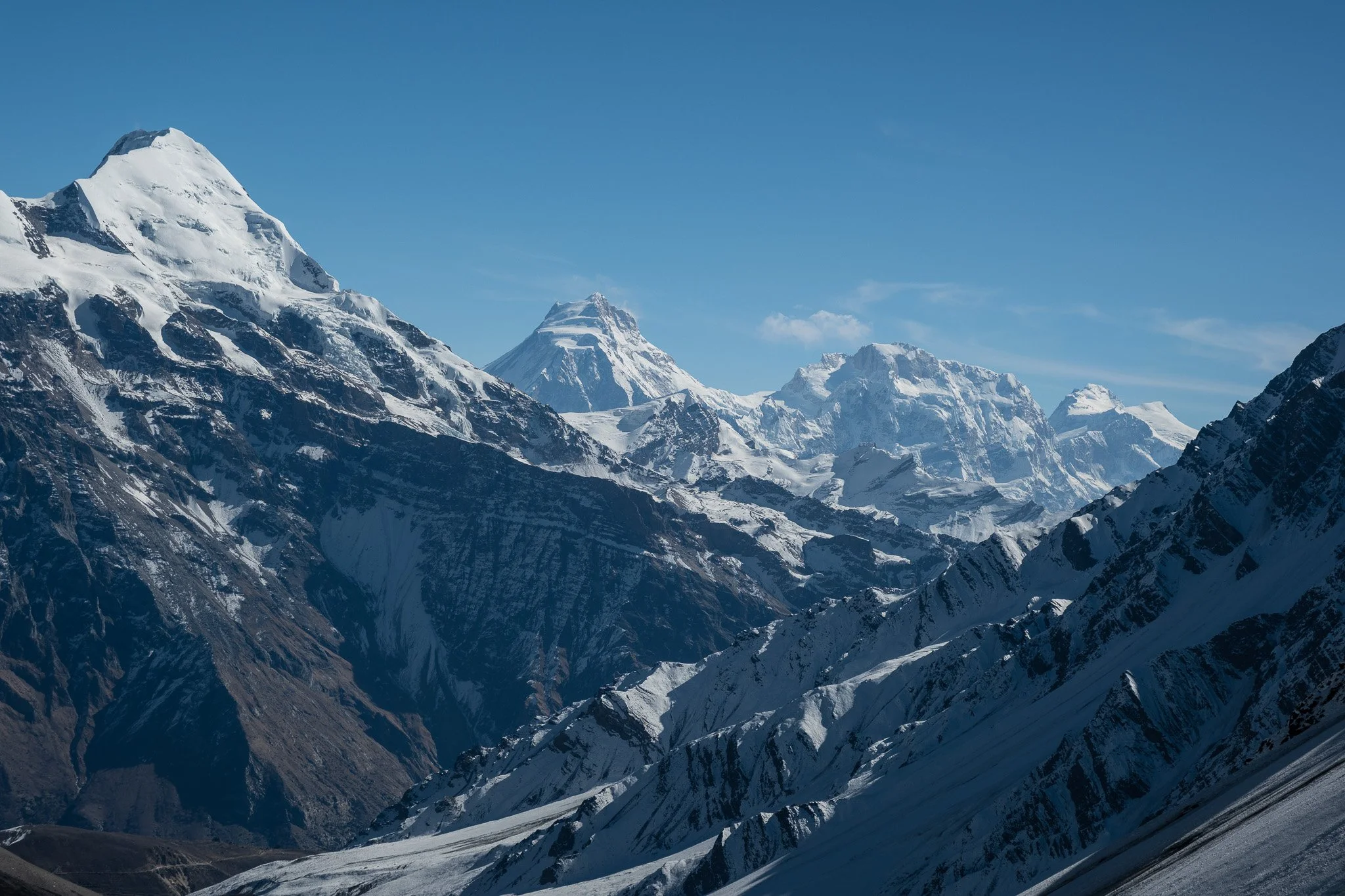
For the adventurous, there is the option of crossing the very hard Kang La pass (5320m/17454ft), the trail to which lies west of Nar. That would involve a very early start to the day around 4 a.m. By mid to late morning, you would reach the pass, located precariously on a knife-edge ridge. The view of Annapurna II (7937m/26040ft) from the pass is staggering and unforgettable. The very steep and long descent of 1600m on scree and loose gravel, occasionally ice and soft snow, is equally memorable. Micro spikes that you can easily attach to your hiking boots is a must-bring. You could be a headline of a story in a Kathmandu newspaper if you fall here.
At the bottom of the pass, the large village of Ngawal (3650m/11975ft) is still at least 90 minutes away.
As you descend, there is a fair chance that you see a wandering family of blue sheep.
Day 11: From Koto or Ngawal to Bandipur (1030m)
After no doubt a hot shower, a long night of conversation with your guide and fellow travellers in the cosy dining room of a lodge in Koto or Ngawal, and hours of well-deserved sleep, you make your way out of the mountains.
We choose to transit in Bandipur (1030m/3379ft) today, a charming but often overlooked hilltop town south of the Annapurnas.
Its well-preserved Newari architecture, welcoming inns and homestays, and probably your first Western food menus in days help you to decompress before hurtling back to Kathmandu.
From viewpoints in Bandipur, with a coffee or beer in hand, look back wistfully at the Himalayan mountains from which you just came.
Day 12: Bandipur to Kathmandu
After a few hours, you arrive in Kathmandu after lunch where you can relax and spend the rest of the day exploring the endlessly fascinating city, or shop for souvenirs for folks back home.
Day 13: Goodbye – for now
Bid farewell to your guide or even travel mates as you are being driven to the airport for your departure from Nepal. We look forward to your return some day!
START/END Kathmandu
LODGINGS Hotel/ teahouse
MEALS All inclusive
TRANSPORTATION Private vehicle
BEST SEASON Late March to early December
TRIP DURATION 13 days
TREK GRADING Moderate with a Very Strenuous option
TOP ELEVATION 4200m/13780ft with an option to reach 5320m/17454ft
How Big is Your Trekking Party?
Just myself……….$2,495
Two people……….$1,711 each
Three people……$1,626 each
Four people………$1,456 each
For larger groups, just ask us!
For this trek, the price varies slightly depending on the season. The prices above are for the peak September to November months for the normal route without the Kang La pass option. The special permit needed to enter this restricted border area costs marginally less in other months.
TRIP INCLUDES
Pick up from airport on day of arrival
Hotel stay in Kathmandu for 2 nights and in Bandipur for 1 night
Private vehicle from Kathmandu to trek start point and back
All meals (breakfast/lunch/dinner) en route and during trek, and 3 hot beverages each day of your choice
Stay at teahouses or homestays during trek
English-speaking and government-trained guide
Porters to carry your luggage (ratio of 1 porter to 2 guests)
All necessary paperwork, trekking permits and local taxes
TRIP EXCLUDES
Meals in Kathmandu and Bandipur (except breakfast at hotel)
Visa fees and cost of international travel to and from Kathmandu
Personal expenses
Travel insurance, including coverage for outdoor activities up to 5,000 metres, search-and-rescue in mountainous areas, and costs of helicopter evacuation
Tips for guide, porter(s) and driver(s)