
Location > Nepal > Nar Phu and Annapurna
Overview
The Annapurna Two-Pass Trek is a synthesis of two treks – an adventurous crossing of the very hard Kang La pass (5320m/17454ft) from the little-visited valleys of Nar Phu into the middle section of the Annapurna Circuit, followed by the crossing of a second pass – the iconic Thorong La pass (5416m/17769ft).
The hike to the culturally rich region of Nar Phu serves as an acclimatisation phase for the two big passes and also offers hikers a glimpse into a land that remains a blank on the map for many tourists, including domestic visitors.
Day 1: Arrive in Nepal’s bustling capital of Kathmandu
The vast majority of visitors from around the world fly into Kathmandu, a sprawling city of more than 1.6 million people. As you step out of Tribhuvan International Airport, you will be greeted by your guide or a company representative who will drive you to your hotel. After finalising your itinerary with your guide at the hotel and answering any remaining questions you might have, you are free to go explore the warrens of colourful alleyways and tourist attractions in downtown Kathmandu. Restaurants, bars and shops open till late during peak tourist seasons.
Day 2: Kathmandu to Koto (2620m)
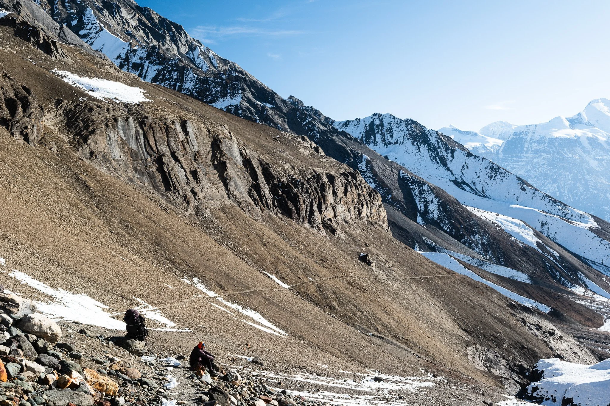
Today’s long drive to Koto, the trailhead of the trek, calls for an early start. As you drive west, Kathmandu’s whirring web of winding roads and alleyways quickly disappear into the rear view mirror. Once out of the Kathmandu valley, you slip into the busy NH17, or the Prithvi Highway, which connects the capital with the lakeside city of Pokhara. Pass by picturesque villages and terraced fields along the Prithvi Highway, named after the first monarch (1723-1775) of the unified Kingdom of Nepal. After your lunch stop, you make a sharp turn and enter a narrow valley. The tarred motorway soon becomes a single-lane road of dirt and potholes. Driving exclusively on steep slopes from this point, your route runs parallel to the Marsyangdi, a river that will undergo an irreversible change when a Chinese-funded hydropower project is completed despite objections from local communities. By the late afternoon or early evening, you arrive at the town of Koto (2620m/8596ft), part of the traditional Annapurna Circuit.
Day 3: Koto to Cha Cha (2960m)
After an early breakfast at your lodge, your paperwork will be verified by the police at the Koto checkpoint. To enter Nar Phu, you need to pay for a special permit, which is needed for many areas that share an international border with Tibet in China. Step off the Annapurna Circuit and enter a deep gorge to the north. Ascend the narrow valley through pine forests by the Nar Khola (river). Your lunch stop will be at Cha Cha (2960m/9711ft), a small cluster of teahouses in the woods where you will also stay for the night.
Here, you encounter hikers rushing from Koto to Meta (3520m/11548ft), where they will likely arrive fatigued after a long 9-hour day and a sharp 900m ascent, exposing themselves to acclimatisation problems. We do not recommend arriving at Meta on the first trekking day at all. Altitude problems at this early stage will have a ripple effect on the rest of the itinerary, jeopardising the chances of you successfully completing your journey.
After a few hours, the gorge finally opens up and you arrive at Meta, a large Tibetan-influenced village on the lower slopes of the imposing 6981m (22904ft) Kang Guru. In the warmer months, the cultivated fields and terraces in Meta and other villages become a sea of unbelievable green, turning the Nar and Phu valleys into long corridors of unsurpassed natural beauty. Looking back, the pointed peak of Annapurna II (7937m/26040ft) and its offspring, the 6983m (22910ft) Lamjung Himal, command the southern horizon.
Day 5: Meta to Chyakhu (3780m)
Like the previous day, the way to your destination today – the village of Chyakhu – is not long. We highly recommend this short day as an acclimatisation day. Hikers rushing from Meta to Phu in one day would expose them to acclimatisation problems.
After lunch at Chyakhu, consider exploring the area in the afternoon. Get the owner of your guesthouse to take you on a side-trip to the upper flanks of Kang Guru. You wouldn’t need to go too high for gorgeous views of the valley and beyond. Or spend the time exploring a former Khampa settlement in Chyakhu.
The Khampas were Tibetans from the province of Kham in Tibet in the early 20th century. After the invasion of Tibet by Chinese forces in 1950, many Khampas used the northern areas of Nepal including Nar Phu, Samdo in the Manaslu area, and Upper Mustang, as bases to stage guerrilla warfare on Chinese troops in Tibet. That ended when the CIA stopped backing them after the historic visit of former U.S. President Richard Nixon to China in 1972. The Khampa warriors were then disarmed by Nepal and resettled. In later years, they were relocated to cities such as Kathmandu. Some migrated overseas, especially to India. The remains of those resettlements can be seen in Chyakhu, as well as Junam and Kyang.
Day 6: Chyakhu to Phu (4050m)
Bidding farewell to Chyakhu, you continue your journey on the broad lower slopes of Kang Guru until you reach Kyang (3850m/12631ft), previously a Khampa settlement. The villagers of Phu usually bring their yaks down to Kyang for the winter. Have an early lunch here. There is no other settlement between Kyang and Phu.
The passage to Phu (4050m/13287ft) dramatically narrows after Kyang. From Kyang to Phu, the route is but a slender trail of dirt and loose gravel etched into precipitous cliffs.
Phu, like Nar, is a vertical cluster of medieval stone houses built on terraces connected by a warren of alleyways. High above Phu lies the Samdu Choling Gompa. The monastery is usually locked, and you would need to hunt down the key master. On the hill behind the village is the Tashi Lhakhang Gompa, regarded as one of the great Buddhist monasteries in the world. Attendance of a puja (prayer session) there would be something special.
If you arrive in the mid-afternoon, consider hiking up to a 4500m (14763ft) viewpoint west of Phu for glorious views of the valley. Ascend an old trail at the western end of the village. Then turn north and continue climbing the ridge-line to the viewpoint as indicated by prayer flags fluttering in the wind.
Day 7: Phu to Nar Phedi (3500m)
After spending some days at elevations of around 3500-4000m, you are in a good position to tackle Kang La pass (5320m/17454ft). The trail to the pass begins at the medieval village of Nar (4200m/13780ft).
Some hikers are told that they could reach Nar from Phu in one day. Indeed, it is possible, but it would be a sprint, not a hike, given the finite daylight hours. We highly recommend staying for the night at Nar Phedi (3500m/11483ft), which lies across the valley from Meta, and head for Nar bright and early on the next day.
Nar Phedi (“Phedi” means “at the foot of”) is not a village but a monastery. At Satek Gompa (“Gompa” means “Monastery”), there is a well-kept guesthouse for hikers.
Day 8: Nar Phedi to Nar (4200m)
After breakfast, we quickly ascend the ridge overlooking Satek Gompa in a series of switchbacks. As you climb higher, the views become increasingly gratifying. When you reach the top, the views are truly outstanding. The size and scale of the Kang Guru massif on the opposite side of the valley become apparent. In its shadow lies Meta. To the north, you can see Chyakhu, and even Kyang, if your eyes are good.
The gates of Nar are just around the corner, though Nar is still 90 minutes away as the trail continues to climb. It takes about 3 hours in total to cover the ascent from Nar Phedi to Nar. Soon, a giant chorten (stupa) and a long mani wall of smaller chortens greet you. You are not far now. From here to Nar, the walk takes just 20 minutes or so.
After lunch, spend the rest of the day exploring Nar. Against the austere backdrop of the now familiar peaks, a sense of peacefulness runs through the village, a reward for your efforts over the past week.
Day 9: Nar to Ngawal via Kang La pass (5320m)
The Kang La pass (5320m/17454ft) is a challenging pass, partly because of the more than 1000m ascent from Nar and partly because hikers have to hike for 2-3 hours before reaching the base of the pass. From the top of the pass, it is a steep but still long descent into the Manang valley of the Annapurna Circuit. This could be minimally a 9-hour day, potentially stretching to a 12-hour trek.
After breakfast, head west of Nar around 4 a.m. As the sun creeps above the horizon to the east, you should reach the final flat plain at an elevation of around 4600m, just 300m higher than Nar. We recommend having a second breakfast here prepared by your lodge, before powering ahead.
Cross a river via a metal bridge and head for the cliff directly ahead of you. A moderate path zig-zags up the slope, where you meet with the first of many white-blue poles that will guide you across the pass to the Annapurna side.
Depending on the time of the year, and also upon the weather, you will either encounter here snowy trails on loose gravel and scree, or a green Eden with yaks grazing peacefully with dramatic peaks piercing the sky as the backdrop. Since we always plan for the worst, bring micro spikes that you can easily attach to your hiking boots if the trail turns icy and slippery.
By mid to late morning, you reach the pass, located precariously on a knife-edge ridge.
Looking back, the 6981m (22904ft) Kang Guru still dominates the horizon, with the crescent-horned summit of the 8163m (26781ft) Manaslu to its right. The 7126m (23379ft) Himlung is a slight bump to the far left. On the other side of the pass, the view of Annapurna II (7937m/26040ft) is staggering and unforgettable. As are the views of the other Annapurna peaks.
The very steep and long descent of 1600m on scree and loose gravel, occasionally ice and soft snow, is equally memorable. At the bottom of the pass, the large village of Ngawal (3650m/11975ft) is still at least 90 minutes away.
Day 10: Ngawal to Manang (3540m)
It will be a short day today after the endeavours the day before. In a few hours, after savouring more National Geographic views, you arrive in Manang (3540m/11614ft), the last major village before Thorong La pass. Spend the rest of the day in a coffee shop or pick up a souvenir at the gift shop next door.
Day 11: Yak Kharka to Thorong Phedi (4450m)
Today will be a long day with a gradual ascent of around 900m. Acclimatised from higher altitudes, you should not be daunted by the altitude change, though it should still be treated with respect.
By midday, you arrive at Yak Kharka (4018m) (literally “a pasture land for yaks”), a cluster of colourful and welcome teahouses where you can have your lunch. In a few more hours, you reach Thorong Phedi (4450m/14600ft), which means “at the foot of Thorong”, your base ahead of your steep walk up to the Thorong La pass the next morning.
Over the decades, the Thorong La pass has attained somewhat of a mythic status on the Annapurna trekking circuit, being literally the high point of a trek that attracts more than 10,000 hikers each year. At 5416m (17769ft), Thorong La is also one of the highest non-technical passes in Nepal accessible to the average hiker.
Day 12: Thorong Phedi to Thorong La Pass (5416m) to Muktinath (3800m)
Rise early for the hike up to Thorong La. The majority of hikers have an early breakfast at 3:30 a.m. and start hiking at 4:00 a.m. Some reach the pass at 8:00 a.m., some at 11:00 a.m.
Two other factors to keep in mind: weather and visibility at the top and recent snow conditions. If the weather unexpectedly gets bad while you are at Thorong Phedi, it would be more prudent to wait it out than to risk getting trapped in a white-out at higher elevations under sub-freezing temperatures (we do have a spare day). Hikers have died at the pass due to adverse weather conditions. Separately, if it had snowed recently, chances are the trails at higher altitudes would have turned icy. Micro spikes which you have already packed with you will come in handy.
Finally, you are at the pass at long last. Celebrate reaching the highest point of your trek surrounded by stunning panoramic vistas. As you start to commence your descent on the other side of the pass, the brown cliffs and peaks of Mustang stare back at you as you enter a dry region historically protected from the Indian Monsoon by 7000-8000m peaks. The descent of 1600m from Thorong La to Muktinath (3800m/12467ft) takes at least two hours and you will arrive just in time for lunch.
If you feel sufficiently revived, do consider visiting the Muktinath temple, sacred to Hindus and Buddhists alike. Each year, hundreds of thousands of pilgrims across India and Nepal visit the temple, dedicated to the Hindu god Vishnu.
Day 13: Muktinath to Lupra (3050m)
Just a 3-hour walk from Muktinath is the delightful village of Lupra, where the practices of Bon, a religion that predates Buddhism, still prevail. Visit the Lupra Monastery, which serves as a hub for Bon teachings. Bon is believed to have emerged in pre-Buddhist Tibet, with roots in shamanistic practices, animism and local folk traditions that connect worshippers with the spiritual realm. With the arrival of Buddhism, many Bon teachings assimilated aspects of Buddhist philosophy to give birth to a tradition known as Bon Buddhism. Buddhists walk round a chortern (stupa) in a clockwise manner; a Bon Buddhist would do that counter-clockwise.
Today is also a spare day for emergencies. If you have already used an extra day earlier, drive straight to Pokhara from Muktinath today.
Day 14: Lupra to Pokhara (822m)
Hike west to the Kali Gandaki river. In an hour, you arrive at the dusty town of Jomsom. A few hardy travellers fly out of the region from Jomsom to Pokhara. But most find it too unnerving to brave the strong Himalayan winds on a tiny propeller aircraft, despite the short 25-minute flight.
You will arrive at the city of Pokhara in the early afternoon, but not before you pass through one of the world’s deepest gorges. Separating the towering Annapurna and Dhaulagiri ranges is the Kali Gandaki, which flows from Upper Mustang, through the Himalayas and later into the Gangetic plain. A narrow unpaved road hugs close to the western Dhaulagiri side of the gorge, the only motorable route that links the region of Mustang with the rest of Nepal. In Pokhara, by the placid surface of Phewa Lake, all the cares of yesterday would seem like a world away. Treat yourself to a well-deserved hot shower and relax in one of the many cafes in the quiet lakeside city.
Day 15: Pokhara to Kathmandu
Enjoy a picturesque morning in Pokhara as you gaze as the reflection of the Annapurna mountains on the surface of Phewa Lake. Take your time to revisit favourite spots (that particular French creperie that must be kept a secret?) before taking the jeep back to Kathmandu. Again, we prefer to travel by road than fly, given frequent flight delays and chaos at the Pokhara airport. With a jeep, leave as and when you like, and stop when and where you wish.
Day 16: Goodbye – for now
Bid farewell to your guide or even travel mates as you are being driven to the airport for your departure from Nepal. We look forward to your return some day!
START/END Kathmandu
LODGINGS Hotel/ teahouse
MEALS All inclusive
TRANSPORTATION Private vehicle
BEST SEASON Late March to May and late September to early December
TRIP DURATION 16 days
TREK GRADING Moderate to Very Strenuous
TOP ELEVATION 5416m/17769ft
How Big is Your Trekking Party?
Just myself……….$2,775
Two people……….$1,815 each
Three people……$1,732 each
Four people………$1,554 each
For larger groups, just ask us!
For this trek, the price varies slightly depending on the season. The prices above are for the peak September to November months. The special permit needed to enter Nar Phu costs marginally less in other months.
TRIP INCLUDES
Pick up from airport on day of arrival
Hotel stay in Kathmandu for 2 nights and in Pokhara for 1 night
Private vehicle from Kathmandu to trek start point and back
All meals (breakfast/lunch/dinner) en route and during trek, and 3 hot beverages each day of your choice
Stay at teahouses or homestays during trek
English-speaking and government-trained guide
Porters to carry your luggage (ratio of 1 porter to 2 guests)
All necessary paperwork, trekking permits and local taxes
TRIP EXCLUDES
Meals in Kathmandu and Pokhara (except breakfast at hotel)
Visa fees and cost of international travel to and from Kathmandu
Personal expenses
Travel insurance, including coverage for outdoor activities up to 5,500 metres, search-and-rescue in mountainous areas, and costs of helicopter evacuation
Tips for guide, porter(s) and driver(s)