
Location > Nepal > Manaslu
Overview
In slightly over a week, hikers ascend more than 4000m from Nepal’s steamy subtropical jungles to the snowy Larke La pass at 5106m (16752ft). Apart from the diverse natural landscapes on the Manaslu Circuit, the crescent-horned summit of Manaslu itself is a sight to behold. Fit travellers can also hike to Nepal’s border with Tibet as a side trip - another feature unique to the trek.
Our itinerary is based on a survey trip in 2025 and avoids the excessively long days found on more traditional itineraries crafted in the days when teahouses were scarcer. That said, the Manaslu Circuit is still demanding, with its many ups and downs, even at lower elevations. The dramatic 1600m (5249ft) descent from Larkya La (also spelled Larke La) pass to the other side in just a few hours cannot be avoided. Those with bad knees have been warned.
Day 1: Arrive in Nepal’s bustling capital of Kathmandu
The vast majority of visitors from around the world fly into Kathmandu, a sprawling city of more than 1.6 million people. As you step out of Tribhuvan International Airport, you will be greeted by your guide or a company representative who will drive you to your hotel. After finalising your itinerary with your guide at the hotel and answering any remaining questions you might have, you are free to go explore the warrens of colourful alleyways and tourist attractions in downtown Kathmandu. Restaurants, bars and shops open till late during peak tourist seasons.
Day 2: Kathmandu to Machhakhola (870m)
Today’s roughly 8-hour drive from Kathmandu to Machhakhola (870m/2854ft) calls for an early breakfast and early departure. After you wind along the mountain roads on the forested slopes of the Kathmandu Valley, you enter the perpetually busy Prithvi Highway, or NH17 for short. A turn soon takes you into the lush, hilly district of Dhading, where you will briefly stop for lunch. Your jeep later crosses the Budhi Gandaki river, which you will follow to its very birthplace in the Manaslu region in the coming days. You pass by Arughat Bazar and nod in homage to its former role as the start of the Manaslu Circuit. Just as the Annapurna Circuit has grown increasingly shorter due to road construction, the start of the Manaslu Circuit has shifted north over the years with a new road. You aim to alight at the riverside village of Machhakhola by mid-afternoon.
Day 3: Machhakhola to Jagat (1340m)
The magnitude-7.8 earthquake in April 2015 shook much of Nepal, tearing down forested slopes and even rewriting some trekking routes. The section of the Manaslu Circuit between Machhakhola (869m/2851ft) and Jagat (1340m/4396ft) is still scarred by landslide zones where the terrain becomes unstable in wet weather. There are two routes from Machhakhola to Jagat – the traditional foot trail on the east side of the river and a less scenic dirt road on the west side used by pack mules and tractors. If the weather has been fine and dry, your guide will pick the route on the east side, where you will pass by traditional villages and home-run teahouses. Stop for lunch at a charming teahouse at the top of a cliff after carefully navigating a landslide zone. About an hour before reaching the village of Jagat, you will encounter a fascinating cantilever bridge supported by steel structures clamped into the rock walls of a mountain.
Day 4: Jagat to Deng (1860m)
Today’s trail is one of contrasting scenes. From Jagat, the valley begins to widen considerably. After crossing a very long (!) suspension bridge to the other side of the valley, you soon spot the welcoming terraced paddy fields of Philim and the first distant glimpses of higher ridgelines. After lunch, the trail continues to cut across lush, fertile field terraces, with Eden-like waterfalls plunging into the Budhi Gandaki river on both sides of the valley and an almost golden light turning everything it touches into a thing of beauty. Cross the suspension bridge just before the entrance to Tsum Valley. Immediately after, you enter a dark, narrow gorge, where you will largely remain for the rest of the day. In the semi-gloom, mind a few short sections of unstable terrain. In about 2 hours, you will see a small cluster of teahouses that make up the village of Deng in the distance.
Day 5: Deng to Ghap (2160m)
Today and the next day will be short trekking days, created for trekkers who might be starting to feel some wear and tear from the ups and downs, or digital content creators who need to upload their files or spend time editing their images - or simply for those who just wish to take it easy. For the power trekkers, you can reach Namrung in one long day and save the now extra day for one of many potential side trips later on the trail.
From Deng, you cross the Budhi Gandaki to the east side of the river and continue your ascent up the valley. Do stop for an early lunch at the tiny and unassuming village of Bur, where, miraculously, you can brew yourself a cup of coffee from an espresso machine! Freshly baked muffins are also available. Stock up on coconut biscuits and other snacks, which you will not find at higher elevations. The village of Ghap is not far away. Stop there for today (stay on the east side of the river), or power ahead to Namrung.
Day 6: Ghap to Namrung (2630m)
Cross the Budhi Gandaki River to its west side, and after several hours of forest trails, you emerge from dense foliage to open views of the mountains. The village of Namrung (2630m/8629ft) is just around the corner. For those with deep pockets or just insatiable curiosity, consider staying a night at the “Nubri Four Season Resort” - an architectural wonder as much as it is an oddity in a village of stone and wooden teahouses. The difference in accommodation costs here will be borne by you. Otherwise, take the regular option!
How far Namrung has come. In a 1980s account by a British climber whom I will not name, he wrote: “The villagers of Namurung, a vile-looking bunch misshapen by goitres, refused to let our porters carry our loads through the village, insisting thattheynow carry our loads to Base Camp at double the daily rate of pay… Expecting at any moment to see daggers drawn and our expedition come to an abrupt end, we held a meeting, extraordinary in every way: a council of war.”
Day 7: Namrung to Shyala (3500m) via Lho
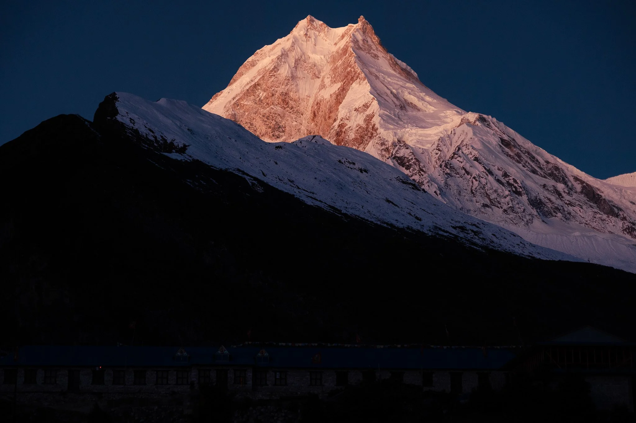
The days of narrow chasms and gloomy woods are now behind us as the valley widens dramatically. Today will also be the day when, up close, Manaslu reveals himself as you approach the picturesque village of Lho (3180m/10433ft). Here, many a photo has been taken of the snow-white Manaslu, with the golden gates to the Ribung monastery providing an iconic foreground. Fit hikers who saved a day earlier may want to spend that extra time here for spectacular sunrise views of Manaslu the next morning and a mini-visit to the Ribung monastery.
After lunch at Lho, you continue your ascent up the valley, passing the conical hill on which the Ribung monastery is precariously perched. The final section of the trail before arriving at Shyala (3500m/11483ft) is a densely forested trek that could be icy, depending on the time of year. Your pace may slow as you start to feel the altitude. Do not rush. Go with the flow and what your body is telling you. The subtropical heat from the lower elevations will also begin to fade from here on.
Shyala is a large village with permanent homes, monasteries, and teahouses. Tip: Choose a teahouse with an open rooftop for unobstructed views of Manaslu at dawn. The views of Manaslu at Shyala are superior to those at Samagaon, whose location is too close to the mountain to offer panoramic vistas of it and the surrounding peaks.
Day 8: Shyala to Samagaon (3520m) with a side trip to Pungyen monastery (4000m)
This day should be treated primarily as an acclimatisation day, with the altitude difference between Shyala and Samagaon nearly on par. A side trip to Pungyen (also spelled Pung Gyen) monastery - lying at a visually arresting alpine pasture at the foot of Manaslu - will also aid in adjusting to the altitude.
Little is known of Pungyen Monastery outside of Shyala and Samagaon, making any interactions with resident monks (when you encounter them) a potentially enriching morning or afternoon. What is known is that the monastery is dedicated to the local protector deity, Pungyen, who lives on Manaslu. Existing literature in the West on Pungyen recounts the winter snowstorm of 1953 that triggered an avalanche, killing 11 people in the monastery, including three nuns. Locals put the blame on a Japanese expedition that tried to summit Manaslu that past autumn, saying the climbers had defiled the slopes of the mountain and angered Pungyen. Local villagers refused to let the Japanese mountaineers ascend the peak when they returned the following year for another summit attempt.
“Life in the harsh, unpredictable environment of Sama (Samagaon) is too often punctuated by sudden tragedies. Despite the constant threats of natural disasters, crop failure, and disease, the people of this village strive on a daily basis to raise their families and live respectable lives,” wrote U.S. anthropologist Geoff Childs in his book Tibetan Diary.
“High on the icy, crystalline peak dwells the deity called Lord Pungyen. Paintings in the village temple depict this protector wearing a white turban, brandishing a sword, and riding a white horse. When properly appeased, he battles enemies lurking in the spirit world. When angered, he can send avalanches tumbling down from the lofty heights on unsuspecting villagers.”
Three years after the incident, Japanese climbers were again met with local resistance. The tensions were later resolved thanks to intervention by a Nepali government official accompanying the expedition, allowing the first summit of Manaslu. Since then, Manaslu has been known as the “Japanese” mountain in the way the British saw Everest as their target peak.
Set off for Pungyen monastery early to catch the sublime mountain light, leaving your bags at the teahouse. The return side trip should take 4 hours at the most. Retrieve your bags on your return and proceed to Samagaon, which is but an hour away on foot. You can lunch in either Shyala or Samagaon.
If you had powered ahead from Namrung to Deng in a day, you can use the extra day in Samagaon (3520m/11549ft) for a side trip to Manaslu Base Camp (4800m/15748ft) and to further acclimatise. Even climbing part of the way will be helpful.
Day 9: Samagaon to Samdo (3875m) with a potential side trip to the Tibet border
The heavily Tibetan-influenced village of Samdo (3875m/12713ft) is a 4-hour walk from Samagaon.
Here, the mountainous and rugged border with Tibet is but a political demarcation. The invisible boundary is porous, with multiple high-altitude passes allowing two-way travel if you wish (at the risk of being caught on the Chinese side).
The “official” route into Tibet is via the 4998m (16398ft) Rui La pass, a 5-hour one-way hike north of Samdo. If you have a spare day from your power walk from Namrung to Deng earlier, consider spending it here on this route. A side trip to Rui La pass and back to Samdo will be a 9-hour trek.
The nearest route to Tibet from Samdo is via the 5120m (16798ft) Lajyung pass. But the trail is said to be vague and unclear.
If you only have one afternoon to spare, consider climbing to (or towards) the top of Samdo Peak, the 5177m “hill” overlooking Samdo the village. The high vantage point, reached through a series of zigzag switchbacks up a barren and rugged slope, offers unique 360-degree panoramic views of the region.
Day 10: Samdo to Dharamsala (4460m)
The 4- to 5-hour straightforward trek from Samdo to Dharamsala (4460m/14632ft) is the final section of the trek before crossing Larke pass.
Dharamsala is not a village but a cluster of three very basic teahouses communally run by the villagers of Samdo. Meals are primitive. Do not count on comfort. But it is an (almost) essential stop for your attempt to cross Larke pass. They close entirely from mid-December, as Dharamsala is not a permanent settlement.
Aim to arrive at Dharamsala as early as you can. The number of rooms here is extremely finite, often snapped up by large trekking groups.
Tip: As a precautionary measure, have your swift-footed guide or porter race ahead to secure rooms first. If there are no rooms left - particularly during the peak trekking months - you will have to stage your Larke pass crossing from Samdo.
Day 11: Dharamsala to Bimthang (3590m) via Larke pass (5106m)
From Dharamsala to Larke pass to Bimthang on the other side is a long ascent and a very steep descent that can take anywhere from 9 to 12 hours, depending on your fitness and how well acclimatized you are. Unlucky trekkers who start the ascent from Samdo face a potentially 16-hour day.
Those departing from Dharamsala typically leave for the pass at 4 a.m. The initial climb follows a very rocky trail along the Larkya Glacier, an eerie tongue of ice under the dim starlight that will be your voiceless companion for the next two hours or so. Micro spikes, which you can buy at very affordable prices in Kathmandu, will be needed if the route is icy and slippery.
The route, marked by black and yellow poles, then enters a snowy plateau of undulating hills. Views of the alpine backcountry here are literally breath-taking.
Larke pass is a small dip on a broad saddle between mountains. Some trekkers, acclimatised from earlier side trips on the trek, arrive at the pass as early as 7 a.m. Others check in at 10 a.m. Large groups moving at a glacial speed may show up as late as 4 p.m.
The way to the village of Bimthang from the pass involves a steep 1600m descent. The crossing will also officially mark your exit from Manaslu and your entry into the Manang district of the Annapurna region. Have lunch at Bimthang Phedi, a tiny cluster of teahouses at the foot of the pass.
Nearly every hiker who arrives in Bimthang arrives wrecked. Some can’t help but doze off immediately. You may want to stay at Cheers Lilita, a clean and cosy guesthouse run by a friendly and funny Tilije villager, Lilita!
Day 12: Bimthang to Tilije (2300m)
The trek from Bimthang to the large village of Tilije - for the ride out of the area - is a gradual descent of nearly 1300m through alpine forests, meadows and terraced farmlands. Stay at a lodge in Tilije. Do not be tempted to trek further to Dharapani, which is currently plagued by the construction of a massive hydropower project.
Day 13: Tilije to Bandipur (1030m)
Plan to transit in Bandipur (1030m/3379ft) today, a charming but often overlooked hilltop town south of the Annapurnas.
Its well-preserved Newari architecture, welcoming inns and homestays, and likely your first Western-style menus in days will help you decompress before hurtling back to Kathmandu.
From viewpoints in Bandipur, with a coffee or beer in hand, look back wistfully at the Himalayan mountains you've just traversed.
The stay in Bandipur also serves as a spare day in case your ascent to Larke pass is delayed. If that happens, you'll skip Bandipur and drive directly from Tilije to Kathmandu in one day.
Day 14: Bandipur to Kathmandu
After a few hours on the road, you arrive in Kathmandu after lunch where you can relax and spend the rest of the day exploring the endlessly fascinating city, or shop for souvenirs for folks back home.
Day 15: Goodbye – for now
Bid farewell to your guide or even travel mates as you are being driven to the airport for your departure from Nepal. We look forward to your return some day!
START/END Kathmandu
LODGINGS Hotel/ teahouse
MEALS All inclusive
TRANSPORTATION Private vehicle
BEST SEASON Late March to May and late September to early December
TRIP DURATION 15 days
TREK GRADING Moderate to Very Strenuous
TOP ELEVATION 5106m/16752ft
How Big is Your Trekking Party?
Just myself……….$2,880
Two people……….$1,916 each
Three people……$1,839 each
Four people………$1,653 each
For larger groups, just ask us!
For this trek, the price varies slightly depending on the season. The prices above are for the peak September to November months. The special permit needed to enter the Manaslu region costs marginally less in other months.
TRIP INCLUDES
Pick up from airport on day of arrival
Hotel stay in Kathmandu for 2 nights and in Bandipur for 1 night
Private vehicle from Kathmandu to trek start point and back
All meals (breakfast/lunch/dinner) en route and during trek, and 3 hot beverages each day of your choice
Stay at teahouses or homestays during trek
English-speaking and government-trained guide
Porters to carry your luggage (ratio of 1 porter to 2 guests)
All necessary paperwork, trekking permits and local taxes
TRIP EXCLUDES
Meals in Kathmandu and Bandipur (except breakfast at hotel)
Visa fees and cost of international travel to and from Kathmandu
Personal expenses
Travel insurance, including coverage for outdoor activities up to 5,500 metres, search-and-rescue in mountainous areas, and costs of helicopter evacuation
Tips for guide, porter(s) and driver(s)