
Location > Nepal > Manaslu
Overview
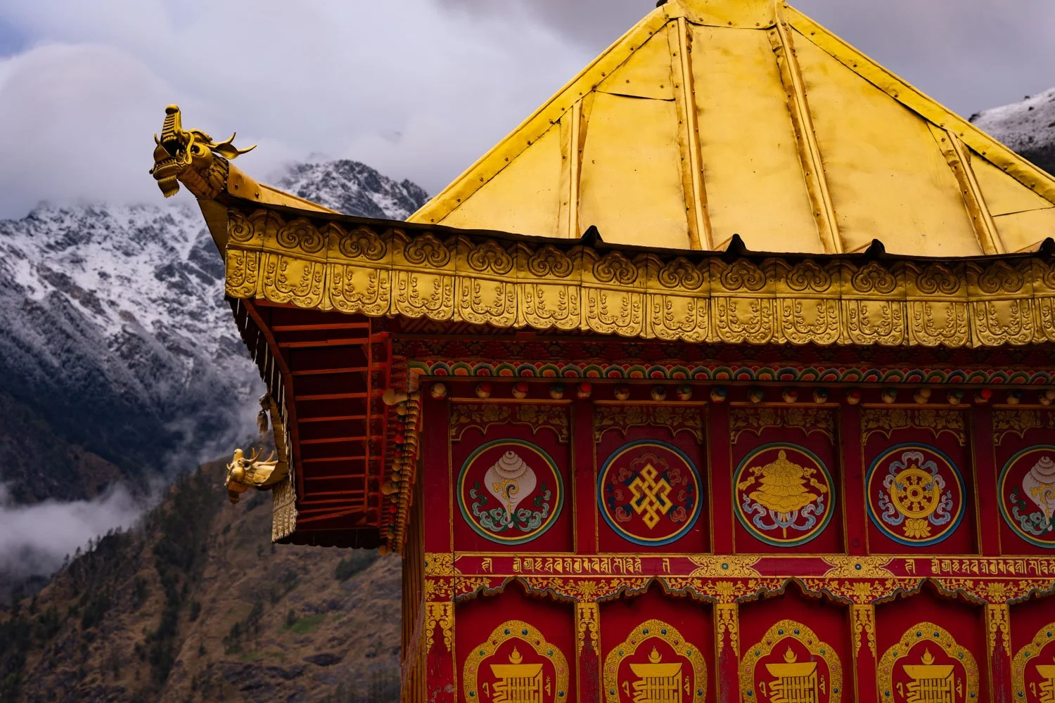
Tsum Valley is situated in the northeastern quadrant of the Manaslu region near Nepal’s border with Tibet in China. A secluded valley of remarkable Himalayan biodiversity, it is also a beyul, a spiritual refuge in Tibetan Buddhism. It is also a self-declared valley of non-violence, where the hunting, killing and sale of animals is forbidden – a true paradise for vegetarian trekkers! Upper Tsum was declared a non-violent zone around 1920 through a common agreement among its villages. Lower Tsum made a similar commitment in 2012.
Tsum Valley and the Manaslu Circuit are part of the Manaslu Conservation Area (MCA), a protected area of 1663 sq km (642 sq miles) inhabited by around 9000 inhabitants, more than 700 species of plants, 200 species of birds and about 40 species of mammals including the snow leopard, Himalayan Tahr, musk deer and Asian black bear. Through the MCA, established at the end of 1998, Nepal aims to manage tourism development that supports the local economy as well as the area’s biodiversity and ecology.
For trekkers, Tsum Valley is a “gentler” version of the Samagaon valley on the Manaslu Circuit, lying at a relatively low elevation of 2200m (7218ft) to 3700m (12,139 ft), though its trails are not without sudden sharp ascents and descents, especially in Lower Tsum. As the valley broadens out in Upper Tsum, it is nearly flat, suitable for a wide range of trekkers, including seniors.
The many well-preserved Tibetan monasteries and nunneries, the spiritual hubs of the valley’s inhabitants, as well as the many chortens (stupas) and mani walls (prayer walls) linking the villages, will fascinate trekkers with an interest in Tibetan Buddhism or Himalayan culture.
Trekkers will also encounter the valley’s fearless mammals along the way, including the normally shy musk deer and families of black-faced langur monkeys. Visitors do not need to stray far from the trails to see plants and flowers unique to the Himalayas, including rhododendrons, Nepal’s national flower, which bloom in spring.
Comfortable lodges also beckon visitors with more time to stay a little longer. An optic fibre now runs through the valley, offering villages with little to no mobile phone connectivity to the outside world. That is also a boon to visiting digital content creators.
Day 1: Arrive in Nepal’s bustling capital of Kathmandu
Most visitors from around the world fly into Kathmandu, a sprawling city of more than 1.6 million people. As you step out of Tribhuvan International Airport, you will be greeted by your guide or a company representative who will drive you to your hotel. After finalising your itinerary with your guide at the hotel and answering any remaining questions you might have, you are free to go explore the warrens of colourful alleyways and tourist attractions in downtown Kathmandu. Restaurants, bars and shops open till late during peak tourist seasons.
Day 2: Drive from Kathmandu to Machhakhola (869m)
The roughly 8-hour journey to Machhakhola (870m/2854ft) near Nepal’s border with Tibet will be a scenic drive, first through the forested slopes of the Kathmandu Valley, then past the lush, hilly district of Dhading. Your jeep later crosses the Budhi Gandaki river, and you arrive at Arughat Bazar, which once served as the traditional starting point of the Manaslu Circuit - a route you will partly follow on the approach to Tsum Valley in the coming days. Arrive at the riverside village of Machhakhola by mid-afternoon at the very latest.
Day 3: Trek from Machhakhola to Jagat (1340m)
The magnitude-7.8 earthquake in April 2015 shook much of Nepal, tearing down forested slopes and even rewriting some trekking routes. The initial leg of the Manaslu Circuit between Machhakhola (869m/2851ft) and Jagat (1340m/4396ft) is still scarred by landslide zones. There are two routes from Machhakhola to Jagat – the traditional foot trail on the east side of the Budhi Gandaki river via the village of Dobhan or a less scenic dirt road on the west side used by pack mules and tractors. The eastern route, with its charming villages and family-run teahouses, is preferred. After Dobhan, you need to navigate a landslide zone for 15-20 minutes. As you climb out of the rocky exposed slopes, stop for lunch at a charming teahouse atop a cliff in Yaruphant and take in the grand mountain scenery as the valley opens up before you. About an hour before the village of Jagat, you encounter a fascinating cantilever bridge system held up by steel structures clamped into the rock walls of a mountain.
Day 4: Trek from Jagat to Chisopani (1620m) (via Philim)
As you leave Jagat, your permits will be checked as you enter the Manaslu Conservation Area (MCA). After crossing an extremely long suspension bridge over the Budhi Gandaki River, you soon spot the welcoming terraced paddy fields of Philim and the first distant glimpses of higher ridgelines. Chisopani (1620m/5315ft), a small cluster of teahouses, is about an hour away. After dropping your bags and tucking into a serving of dal bhat or two, consider a walk to the long suspension bridge about 10 minutes from Chisopani, where you can gain stupendous views up and down the valley of the raging Budhi Gandaki.
Day 5: Trek from Chisopani to Chumling (2386m)
About an hour from Chisopani, the path splits - those continuing on the Manaslu Circuit cross a suspension bridge as they head towards the village of Deng. As you ascend towards Tsum Valley, the trekking crowd starts to thin. After a series of zigzags and a walk through a dimly lit forest, you arrive at Lokpa (2240m/7349ft), a small village perched on a steep slope. Peering down, you realise the raging Budhi Gandaki has given way to one of its tributaries, the Shiyar Khola. You are now in Tsum Valley! The river, crystal clear on most days but milky after a storm, originates from glaciers in the upper highlands of Tsum Valley on Nepal’s border with Tibet, China.
After lunch, carefully cross a landslide zone, then descend to an elevation roughly level with the Shiyar Khola. The trail soon ascends steeply, requiring crossing a long cantilever bridge that hugs the cliff in one section. The ascent continues for another hour before the trail tops out and then drops sharply back to the river. The village of Chumling (2386m/7828ft) is not far now. After crossing a suspension bridge, you zigzag up the other side of the valley. Through occasional mist and cloud, you spot Chumling in the distance, no more than 30 minutes away.
Day 6: Trek from Chumling to Chhokang Paro (3031m)
Chhokang Paro, gateway to Upper Tsum, is not far from Chumling, but the section of the trail after lunch is steep and relentless. Brace yourself!
The trail out of Chumling is fairly level, and after an hour or two, drops to the level of the Shiyar Khola river. The antiquated village of Ripchet on the other side of the valley is visible, and, weather permitting, the snowy white summit of Ganesh II (7117m/23353ft) can be seen rising far above it. Have an early lunch at Rainjam, where views of the Ganesh Himal mountain chain can be had. The other lunch stop option is the slightly claustrophobic hamlet of Gho, about 30 minutes ahead. The trail climbs sharply from Gho. The effects of the altitude will start to be felt. Keep it slow and easy. After 2–3 hours, you arrive at Chhokang Paro, where giant chortens and fluttering prayer flags come into view, with Himalayan griffons soaring overhead.
A relatively large village, Chhokang Paro is the administrative centre of the entire Tsum. It sits at the edge of a broad hanging valley that makes up Upper Tsum, a dramatic departure from the deep and narrow chasm that defines Lower Tsum. Eden-like, with unreal views of the Himalayan alps, Chhokang Paro is the perfect place to be based for a few days if time allows.
Day 7: Trek from Chhokang Paro to Chhule (3347m)
The trail from Chhokang Paro to Chhule is one of the highlights of the trek, a section populated by chortens, mani walls, monasteries, and even a sacred cave.
As you leave Chhokang Paro, a sea of green or yellow awaits you, depending on the growing season. Potato, buckwheat and mustard are typically planted in the spring. By the autumn, the same fields give way to the growing of winter wheat. In the fields, families of black-faced langur monkeys are often seen digging up potatoes and eyeing passersby with acute curiosity. Keep a respectable distance! The village of Lamagaon marks the northern limits of the fields. From Lamagaon, you spy the large chorten of Rachen Gompa across the river, a hundred-year-old nunnery.
Shortly after Lamagaon, you arrive at the small settlement of Burji, from which a trail leads to the famous Milarepa’s Cave on a nearby hillside. Milarepa was an 11th century saint, poet and yogi revered by Tibetans. It is believed that he dwelled in the cave near Burji for a few years, subsisting on nettles as he meditated. The entrance to the cave is likely locked. Seek out the keeper of the key in Burji.
Between Burji and the next settlement of Phurbe, the trail hugs close to the western slopes of the valley, on which Himalayan tahrs, with their striking curved horns, are frequently sighted. With their long, brown coats, Himalayan tahrs blend easily into the environment, and you may not notice them until they are but metres away!
You soon arrive in Chhule (3347m/10981ft), where you stay for the night. Additional accommodation can be found minutes away in the adjacent village of Nile.
After a late lunch in Chhule, consider a short hike to Gonhgye Gompa, a nunnery perched on the hillside with stupendous views of Upper Tsum. East of the nunnery, you see waterfalls tumbling down a steep slope from the high glacier valley of Poshyop above. A treacherously icy route is said to exist between Poshyop and Kyirong in Tibet across the border.
Day 8: Trek from Chhule to Mu Gompa (3700m) (or back to Chhule)
Mu Gompa (3700m/12139ft), a small monastery perched on a high slope, is the northernmost stop of the Tsum Valley trek. The gompa houses a large collection of Tibetan Buddhist texts and walls of fascinating terracotta statues of Buddhist deities made from clay. It is possible to spend a night here, but with just 12 rooms for guests, accommodation is not a guarantee. A trail from the rear of the gompa leads to the very old Dhephyudonma Gompa, which you can consider visiting on your way out. North of Mu Gompa, there is no permanent settlement. To the northeast is the 5093m (16708ft) Ngula Dhojyang Bhanjyang pass that offers access to the village of Kyirong in Tibet. Travellers with more time can consider exploring the pass, but come equipped with a tent and food. It takes at least two days and one night to reach the pass from Mu Gompa.
Day 9: Trek from Mu Gompa/Chhule back to Chhokang Paro
The way back to Chhokang Paro is easy and leisurely. Consider exploring Rachen Gompa en route. There should also be time to clamber up the slopes of Chhokang Paro for glorious views of the Ganesh Himal.
Day 10: Trek to Gumba Lungdang (3300m) (via Gho)
You leave for Gumba Lungdang today, the final highlight of the trek. The location of the nunnery, situated in a dense rhododendron forest at 3300m (10827ft), offers a fantastic view of Ganesh I (7422m/24350ft). En route, the snowy slopes of Ganesh II and Ganesh IV are closer than ever before. It is inexplicable why the nunnery is omitted from many trekking itineraries.
It takes around an hour to descend from Chhokang Paro to Gho, where you can have an early lunch. From Gho, make your way down to the river and cross over to the other side where the trail zig-zags up through a forest of pine, oak and rhododendron on a steep hillside. A series of five chortens marks the way before you arrive at the chorten gate of the nunnery. Attend the evening puja (prayers) and overnight at the nunnery, where the windows of guest rooms strategically open to stunning mountain views. Tents are available at the nunnery should all nine guest rooms be taken.
For power trekkers and those with more time to spare, consider a long hike the following day to Ganesh Himal Base Camp (4200m/13780ft) and back. During peak seasons, tents and basic meals are available at the base camp at the foot of Ganesh I should visitors run out of time and can’t return to the nunnery before sunset.
Day 11: Trek to Lokpa (2240m) (via Ripchet)
Today is a day of mostly descents with a few easy uphill sections as you make your way out of Tsum Valley. After bidding farewell to the ani (nuns) of Gumba Lungdang, retrace your steps down to the valley floor. Instead of crossing the river, swing west past the village of Domje. In 1-2 hours, you reach Ripchet (2470m/8100ft), a very narrow village sitting atop a shelf on an otherwise very steep slope. Have lunch at a lodge next to a monastery and admire the equally narrow terraced fields of the village. Beyond Ripchet, the trail makes a very sharp descent to the Shiyar Khola river. From the suspension bridge where you previously crossed to get to Chumling, retrace your steps to Lokpa, where you will spend your final night in Tsum Valley.
Day 12: Trek to Yaruphant (1170m)
Leaving Tsum Valley, you return to the Manaslu Circuit, retracing your way back to Chisopani, then Philim, and later Jagat. Keep going until you arrive at Yaruphant (1170m/3838ft), where you had lunch on your first trekking day. Overnight in one of the airy cabins on the hillside.
Day 13: Trek to Machhakhola (869m)
Today is a relatively short day as you hike back to Machhakhola. On the way, you will pass by Tatopani, where natural hot springs will tempt you to take a mid-morning break and soak your feet in their healing waters! Back at Machhakhola, celebrate your return from a memorable trek with a beer or a long hot shower. There is an option of taking a local jeep to Arughat Bazar and overnight there instead of Machhakhola, thereby shortening your drive back to Kathmandu on the next day.
Day 14: Drive back to Kathmandu
From Machhakhola or Arughat Bazar, drive back to Kathmandu. You should arrive by noon or in the mid-afternoon.
Day 15: Spare day in Kathmandu
This is a built-in buffer day for any delays. If all has gone smoothly as planned, utilise it for optional sightseeing tours in or around Kathmandu. Visit Boudhanath or the “Monkey Temple”, spend time recovering at a spa, or explore bustling and colourful local markets.
Day 16: Goodbye – for now!
Bid farewell to your guide or even travel mates as you are being driven to the airport for your departure from Nepal. We look forward to your return some day!
START/END Kathmandu
LODGINGS Hotel/ teahouse
MEALS All inclusive
TRANSPORTATION Private vehicle
BEST SEASON Late March to early June and late September to early December
TRIP DURATION 16 days
TREK GRADING Moderate with Strenuous options
TOP ELEVATION 3700m/12139ft
How Big is Your Trekking Party?
Just myself……….$2,375
Two people……….$1,650 each
Three people……$1,600 each
Four people………$1,450 each
For larger groups, just ask us!
For this trek, the price varies slightly depending on the season. The prices above are for the peak September to November months. The special permit needed to enter this restricted border area costs marginally less in other months.
TRIP INCLUDES
Pick up from airport on day of arrival
Hotel stay in Kathmandu for 3 nights
Private vehicle from Kathmandu to trek start point and back
All meals (breakfast/lunch/dinner) en route and during trek, and 3 hot beverages each day of your choice
Stay at teahouses or homestays during trek
English-speaking and government-trained guide
Porters to carry your luggage (ratio of 1 porter to 2 guests)
All necessary paperwork, trekking permits and local taxes
TRIP EXCLUDES
Meals in Kathmandu (except breakfast at hotel)
Visa fees and cost of international travel to and from Kathmandu
Personal expenses
Travel insurance, including coverage for outdoor activities up to 4,000 metres, search-and-rescue in mountainous areas, and costs of helicopter evacuation
Tips for guide, porter(s) and driver(s)